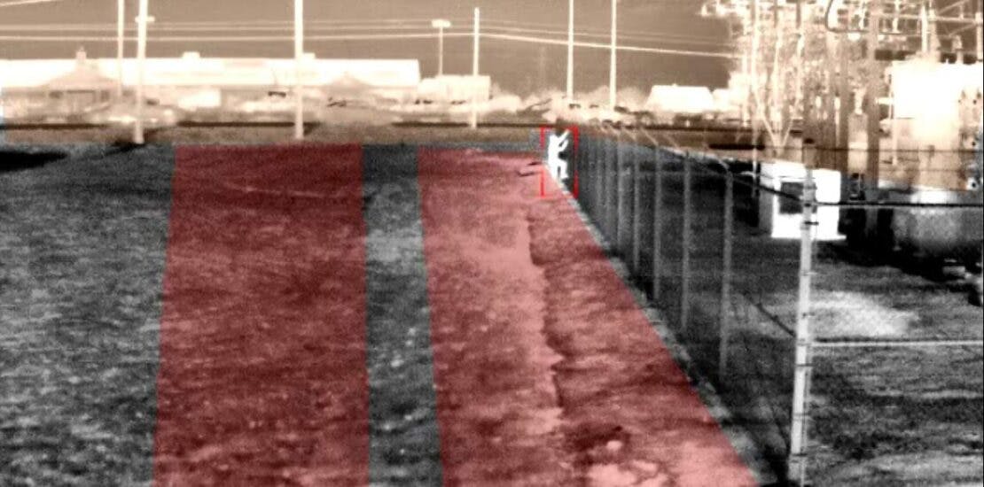
Smart security cameras use video analytics to detect intruders by automatically “seeing” movement and sending alerts. While this solution works quite well in stable, indoor environments, just imagine what a smart camera must contend with outdoors – where everything moves, all the time. Trees sway in the wind, debris blows across the ground and small animals cross the camera’s field of view – all this movement has to be ignored by the camera or it will send hundreds of false alarms to the monitoring center.
And of course, in the middle of all this movement, the bad guy must be detected, every time, and without fail.
At one time, smart cameras used outdoors led to great disappointment due to excessive nuisance alarms or outright mis-detects. Yet many of today’s smart outdoor cameras are able to protect sites like substations, transportation sites, and fenced yards where lucrative materials are vulnerable to theft with exceptionally good reliability, even with the challenges. And one of the important strategies these successful systems use to reduce nuisance alarms and catch intruders is known as geo-enabled video analytics.
Geo-enabled video analytics work by correlating every pixel generated by the sensor to a point on an internal GPS map of the area under security management. When a camera understands this information, it gives the analytic software inside the camera reliable intelligence about the actual size, location, and bearing of all objects in the field of view. From there, extremely accurate analytic rules can be created to improve detection performance.
How Geo-enabled Analytics Empower Detection Performance
You might ask: how does knowing the actual size and location of an object empower detection performance?
Consider how human vision works. Our eyes give us depth perception. We can look at an outdoor scene and easily tell which objects are close or far, based on their relative size from each other.
Now imagine closing one eye and looking at the same scene. You would lose your sense of depth, the scene would flatten out, and you would have a challenging time determining where things are in relation to each other.
It’s the same with a “one-eyed” camera unless it’s geo-enabled. This approach creates a three-dimensional capability for an outdoor detection camera. For example, to a smart camera, a small animal in the near field will look much larger than a man hundreds of meters away, as you can see in the figure below.
A smart camera needs to ignore the dog while alerting you to the person in the distance, even though the animal will cover more of the camera’s field of view. The same criteria apply to other moving things which are always present outdoors.
With a camera that is geo-enabled, such non-security related movement can be ignored and the camera won’t send needless alarms, because it “knows” that the small object is actually six feet and represents a likely intruder, while the dog, while closer and taking up more of the screen, is actually three feet and likely an animal. The camera will ignore the dog, and detect the person, and the security team charged with protecting site will trust that an alarm triggered is credible, and that a response is urgent.
The Role of Video Processing for Geo-Enabled Analytics
It’s important to understand that not every smart camera uses geolocation. This is because making a camera geo-enabled is a highly processing-intensive task. A camera must process many millions of bits of data every second, day and night, over large areas typical of most perimeters, and calculate the geo-location of every pixel in the scene. And the system must do this while streaming many frames per second.
This is where recent innovations in video processing play a role. Geo-enabled cameras take advantage of today’s highly capable video processors — at the edge, inside the camera and in advance of the video analysis – to turn video sensors cameras into reliable intruder detectors. Only cameras with powerful image processing are up to the task.
Making Geo-enabled Analytics Easy
Geo-enabled analytics might be a complicated process under the hood but activating the capability to the end user is often surprisingly easy. While at one time, geo-enabled cameras required technicians in the field to mark locations using GPS devices, today’s smart cameras are often geo-calibrated when first installed using a single click.
When you first configure a geo-enabled camera, often all you need to do is enter the camera’s height off the ground and click a button. From there, sensors built into the camera will automatically determine its tilt and yaw. This gives the camera three data points – height, tilt, and yaw – from which to calculate the geo-location of each pixel.
Geo-enabled Video Analytic Detection Benefits
Geo-enabled analytics are an important capability from which many benefits flow.
For one, they vastly improve the camera’s intruder detection reliability. When the camera knows the actual size and location of all objects, it can detect a human-sized object but ignore objects that are not human-sized. This automatically eliminates small animals and other distractions from triggering alarms. Geo-registration can also be used as a powerful security policy tool by creating geo-aware detection zones.
Many smart cameras will assign a “tripwire” to the scene; when an intruder crosses this line, an alarm is triggered. While at a first appearance this might seem like good security, in practical application it is highly restrictive.
For one, a tripwire cannot be used to create large buffer zones for early awareness. By the time an intruder has run through the demarcation line, you would have lost valuable response time to intervene. Further, the intruder might have already left the camera’s field of view, leaving you blind to the event that is unfolding.
Tripwires are also vulnerable to false alarms from objects that blow through the scene.
Geospatial analytics go significantly further, allowing you to set zones of detection based on real-world activities – speed, bearing, and geo-location. With this capability, you can create:
- Flexible security policies with geospatial “From-To Zones” that detect people outside the fence only when they move towards the perimeter, which represents a threat – while ignoring those inside the fence, which might not represent a danger.
- Layers of protection – you can place a geo-enabled buffer zone both at the fence to detect perimeter breaches, and also create a blanket of smart detection around internal assets like a control house at a substation, while other traffic flows unimpeded.
- Geo-based mask zones can ignore areas of high traffic from triggering unwanted signals, like highway cars passing outside the fence.
What About Artificial Intelligence?
In recent years, there’s been growing excitement about the role of Artificial Intelligence (AI) in security applications, and with good reason. When paired with a good detection capability, AI can add automatic classification of an object in real time, an important aid to help assess the nature of an alarm once it has been accurately detected.
For example, AI can deliver advanced analytical functions like determining the color vehicle that has been detected, as well as facial detection, people counting, and license plate recognition. All of this information can go a long way toward improving security responsiveness.
Geo-aware Analytics and Situational Awareness
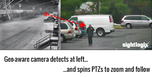
Geo-enabled analytics can also deliver a powerful ability to automatically spin and zoom PTZ cameras directly onto a detected perimeter intruder. This essentially solves two of the biggest challenges for security professionals responsible for outdoor protection – they want to be notified the instant an intrusion takes place, and they want to quickly understand the nature of the threat as a break-in occurs.
While geo-enabled video can solve the first challenge, delivering reliable alarms about where an intrusion takes place, the second concern — the “what” of an unfolding event — can be more difficult to achieve.
Often PTZ cameras are used to watch outdoor areas, but when applied to large areas, a PTZ camera’s narrow field of view relative to the wide areas under surveillance almost guarantees that events will go unnoticed because there’s almost no chance a PTZ camera will be looking in the right place when an intrusion occurs. Trying to manually steer PTZs over outdoor areas is like trying to find a needle in a haystack.
This is where geo-enabled analytics, paired with classification AI can be a huge help. They can use the precise geo-coordinates about the “whereabouts” of an object to automatically direct pan-tilt-zoom (PTZ) cameras to the exact location of an alarm location automatically. From there, smart PTZs can use artificial intelligence to classify the intruder, keeping the target centered in the PTZ and locked onto the threat until it can be safely mitigated.
This capability is shown in the video screen capture. The intruder is detected at distance by a thermal camera (at left), which automatically zooms and follows the target for up-close detail (at right).
The result is a new dimension to security operations, ensuring “eyes on” capability over your entire facility.
In summary, good decisions depend on accurate detection, and the impact of an event unfolding is directly proportional to a security department’s ability to intercept it quickly. Every second counts. Using cameras that are geo-registered to the scene adds a valuable tool to enable comprehensive security throughout a facility, and provides:
- Excellent 24/7 detection performance in all conditions
- An ability to acquire an intruder’s speed, bearing, and geo-location in milliseconds
- Geo-enabled Detection Zones – not tripwires – based on size, speed, bearing, and location
- An ability to automatically spin PTZs to zoom and follow a detected target for real-time assessment
About the author: John Romanowich is the CEO and Co-Founder of SightLogix, a leading smart camera supplier for outdoor security applications. He has three decades of success in building video technology companies, having held management positions with Intel, IBM and the Sarnoff Corporation. He also co-founded Pyramid Vision Technologies, a pioneer in intelligent video acquired by L3 Communications. John is a frequent presenter at security events, including the Security Industry Association (SIA) “Future of Power Grid Security” and the UN’s International Civil Aviation Organization’s “Symposium on Innovation in Aviation Security,” among many others. John is a member of The Monitoring Association (TMA) Surveillance and Video Verification Committee, holds multiple patents in video security technologies, and is the author of the Smart Video Security Handbook.


